

Photogrammetry or LiDAR?
- marcel3875
- Nov 21
- 3 min read
Understanding your data requirements
More and more companies are deploying drones for surveying, inspections and monitoring. A frequently asked question is which sensor fits best: photogrammetry or LiDAR. Both techniques deliver accurate spatial data, but the way they work and the conditions in which they shine differ greatly. Choosing the right approach therefore depends on what you want to measure, how precise the data must be and the environment in which you operate.
Photogrammetry: modelling with images
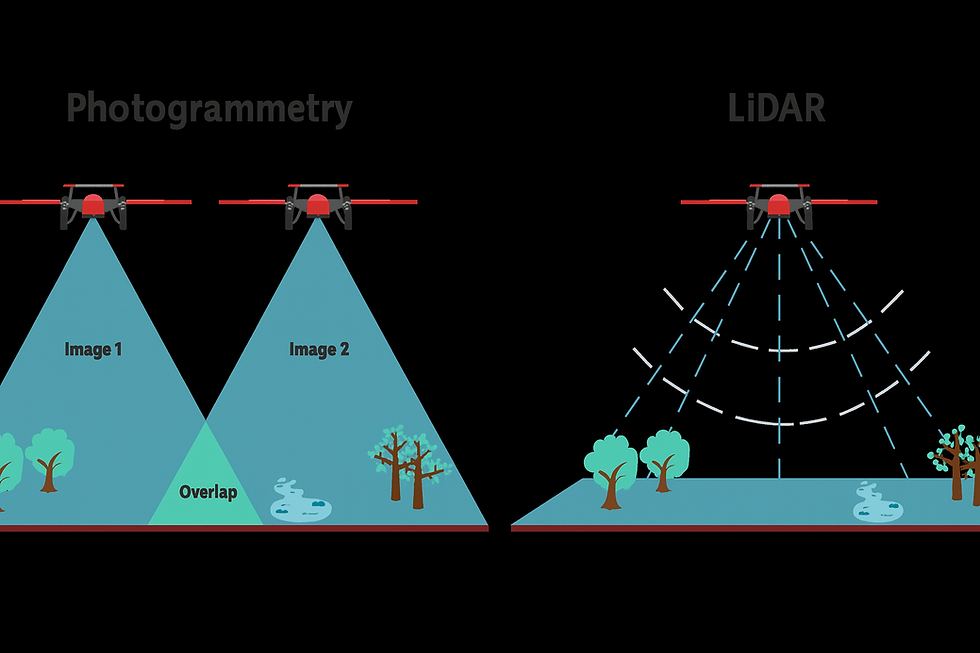
With photogrammetry, high, resolution photos are taken from multiple angles to reconstruct a three, dimensional model. Special software finds matching points in overlapping photos and uses them to build orthomosaics, digital surface models (DSMs) and point clouds. Because the photos contain colour and texture, photogrammetry is ideal for projects where visual context is important, such as construction progress, asset documentation and environmental mapping.
The accuracy of photogrammetry depends on several factors:
• Lighting: diffuse, even light limits shadow distortion.
• Ground Sample Distance (GSD): a lower GSD (smaller pixel size) means higher resolution.
• Overlap and flight altitude: at least 75–85 % front overlap and 65–80 % side overlap ensures full coverage.
• Ground Control Points (GCPs): surveyed reference points link the photomosaic to real, world coordinates.
With good planning using GCPs and RTK/PPK corrections, photogrammetry can achieve centimeter, level accuracy.
LiDAR: measuring with lasers
LiDAR (Light Detection and Ranging) takes a different approach: a sensor emits laser signals and measures the time until the reflection returns. This yields a detailed point cloud that represents the terrain and buildings, even under vegetation. Because it is an active sensor, LiDAR also works in low, light or shaded environments and can “see” through foliage.
Applications where LiDAR is often preferred include:
• Forestry and vegetation analysis – such as mapping tree heights and biomass stocks.
• Corridor mapping and utilities – such as power lines, pipelines or roads.
• Topographic surveys in hilly terrain – where relief and vegetation would otherwise hamper a good measurement.
SLAM LiDAR: positioning without GNSS
In tunnels, dense forests or between tall buildings a GNSS signal is often unreliable or absent. With SLAM LiDAR (Simultaneous Localization and Mapping) a scanner creates a map and simultaneously tracks its own position using inertial and other sensors. This allows drones or handheld scanners to measure accurately indoors or under a closed canopy, without satellite navigation.
Accuracy versus precision
Accuracy and precision are often confused in the drone world, but they are different concepts. Accuracy indicates how close a measurement is to the actual position on the ground, while precision describes how consistent measurements are relative to each other. For example, a photogrammetric model may show very consistent geometry (high precision), yet be offset from the real location if no GCPs are used. LiDAR can achieve both high accuracy and high precision if well,calibrated and combined with RTK corrections. This distinction is essential when defining project requirements and meeting legal standards.
What resolution does your project need?
In photogrammetry the resolution is determined by the Ground Sample Distance, while in LiDAR it’s all about point density. High, resolution photogrammetry (1–2 cm GSD) is suitable for small sites or inspections with a lot of detail, but produces large datasets and longer processing times. A moderate resolution of 3–5 cm GSD often offers a good balance between efficiency and accuracy for construction, mining and civil applications.
With LiDAR the point density depends on factors such as pulse frequency, flight altitude and scan angle. Densities above 200 points per square metre are suitable for fine detail, while 20–50 points per square metre suffice for general terrain models. More data does not always mean better results; excessive resolution can be unnecessarily expensive and time, consuming. It’s about what accuracy and level of detail the application actually requires. By tailoring the resolution to your project goals you reduce storage and processing requirements and keep costs manageable.
Finding the right balance
There is no universal best choice between photogrammetry and LiDAR; each method has its own strengths depending on terrain, desired resolution, budget and regulations. For many projects a hybrid approach offers the best results: LiDAR provides reliable geometry, while photogrammetry adds colour and context.
Our Dutch Wing specialists are happy to advise which sensor or combination is most suitable for your project. With knowledge of both photogrammetry and LiDAR and experience in various Dutch and international environments we help you turn raw data into meaningful insights. Feel free to contact us for a no, obligation conversation about the possibilities.


Comments